Cascade du Ray Pic

Retour
Panorama
1
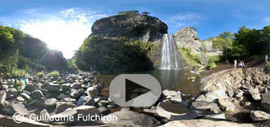
Ouvrir panorama / Open panorama
Photo : août 2007
Panorama
2
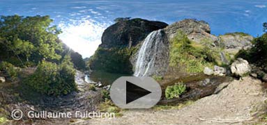
Ouvrir panorama / Open panorama
Photo : août 2007
A mis chemin entre Burzet et Lachamp-Raphèl, la cascade du Ray Pic est un site géologique grandiose. Alimentée par la rivière la Bourges, elle jaillit de 35 mètres au milieu des orgues balsatiques issues d'une des plus longue coulée de lave de France (20km) agée d'environ 35 000 ans.
22 juin 2012 : le site de la cascade du Ray-Pic est de nouveau ouvert au public.
Voir aussi le Mont Gerbier de Jonc
At half way between Burzet and Lachamp-Raphèl, the cascade of Ray Pic is an imposing geological site. Supplied with the river Bourges, it gushes out of 35 meters in the middle of the organ balsatic from one of the longest french lava flow (20km) of approximately 35.000 years old.
June 22nd 2012 : the site of the Ray-Pic waterfall is again open to the public.
See also le Mont Gerbier de Jonc
Plus d'infos / more infos :
Photos : http://www.ardeche-evasion.com/cascade-du-ray-pic.php
Vidéo : http://www.tv-ardeche.com/Le-Ray-Pic.html
Volcanisme en Ardèche : http://www.volcans-ardeche.com/volcanisme/volcanis13.html
Design and panography by Guillaume Fulchiron

